Southwest US trip - Day 4
This post is part 4 of the "southwest_us_trip-2009" series:
- Southwest US trip - Day 1
- Southwest US trip - Day 2
- Southwest US trip - Day 3
- Southwest US trip - Day 4
- Southwest US trip - Day 5
- Southwest US trip - Day 6
::: {style="text-align: center;"}
 :::
:::
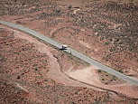
We awoke at sunrise, and broke camp quickly. Due to not taking the Fiery Furnace tour in Arches, and then completing all of the points of interest in Mesa Verde the previous day, we were now nearly a full day ahead of schedule. Our original driving plan for the day was to take US-491 to US-160 right through the four corners area, however with the extra time I suggested that we swing further south into New Mexico and check out Shiprock.
::: {style="text-align: center;"}
 :::
:::
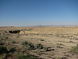
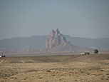
While I did get a few pictures (above) of Shiprock (taken looking southwest), the light wasn't that great by that point in the morning, and they were a bit washed out. Once we drove into the city of Shiprock (named after the geologic landmark), we were supposed to turn onto US-64 westbound, which would then get us onto US-191 in Arizona as we headed back north into Utah. While we had no difficulty finding where US-491 & US-64 merged, we never found where they split off, and ended up continuing unknowingly on US-491. Part of the problem was that there was a large amount of road construction just south of Shiprock, and we're guessing that the turnoff for US-64 was either obscured or removed due to the construction. To make matters worse, we had been driving for nearly an hour before there was another US-491 shield, so it wasn't even obvious that we were on the wrong road until we had driven about 50 of the 91 miles to Gallup, NM. At that point, it seemed silly to turn back (and have to fight through the construction again), so we continued southward and didn't cut west until we hit Navajo-264 (yes, we were driving through the reservation), and then finally headed back north once in Arizona on US-191. In hindsight, we should have just backtracked to find US-64, because we ended up wasting the rest of the morning driving a huge loop from southwest Colorado, into northwest New Mexico, through northeast Arizona, and finally into southeast Utah. If anything, this was an eye opening experience of what the Navajo tribal lands (AKA, reservation) looked like. While we did spend a little time driving across the western edge of the same reservation when we visited the Grand Canyon a few years ago, I never got a good feel for what life was like there. This time was different. While its no surprise that substance abuse & poverty are rampant, seeing this stuff first hand was still an eye opening experience. The few larger towns that we drove through had numerous government agencies setup to help people, and there were various anti-substance abuse billboards sprinkled about. However, its the life outside of the larger towns where its most bleak. Other than basic services, there's nothing out there. Just a few gas stations, convenience stores & the occasional fast food joint. We stopped for lunch (with food that we brought with us) just north of Round Rock, AZ in the only gas station within \~50 miles. Along side the gas station was the post office (which was really just a 15x10 room with mailboxes on 1 wall), a convenience store and the laundromat. That was the entire town's services. Certainly not enough jobs to support any town with more than 10 or 15 people. While eating, we saw an old pickup pull in with several (native american) kids riding in the back. They all got out, and the adult headed to pick up their laundry and refill their propane tank while the kids went into the convenience store. The kids emerged with several bottles of Gatorade and bags of pork rinds. This was Noon. They were eating Gatorade and pork rinds for lunch. Sure, this might have been a fluke, perhaps they eat a (more?) healthy lunch most of the time, but on this day, that was their lunch. One other thing that Denise noticed is that when the kids spoke with the adult (their mother, we guessed), it was always in Navajo, however when they spoke to each other, it was all in English. For the longest time, the reason that I've been told why people are resistant to leaving the reservation is because they'll lose their identity, their culture & their history. However, just from watching this family for a few minutes, it looked like they already gave up those things. They were eating junk food for lunch, and choosing English over their native tongue. It was just bleak & depressing, like entering another country (a 3rd world nation, sadly). Even the gas pumps had Navajo Nation certification stickers, which seemed to me like a waste of resources when your population is living in abject poverty. The only redeeming thing was the gorgeous scenery. Pink & red buttes scattered about the horizon.
::: {style="text-align: center;"}
 :::
:::
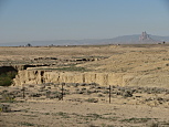
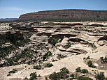
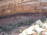
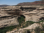
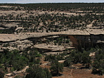
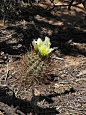
We continued north towards Natural Bridges National Monument in Utah. Natural bridges differ from arches, in that the bridges are formed by flowing water (typically under/through them). Since Natural Bridges was a much higher elevation there was alot of greenery (primarily Pinion Pine & Juniper). The monument is relatively small in size, with a 17 mile loop road that has overlooks for all of the key points of interest. We stopped and saw Sipapu Bridge (above, first from left), the Hourse Collar ruins (above, 2nd from left), Kachina Bridge (above, 3rd from left), and finally Owachomo Bridge (above, 4th from left). Each of the overlooks had a short trail leading with a nice variety of flora. I spotted the hedgehog cactus (above, 5th from left) hiding in full bloom under a pinion pine tree. We completed the full loop in just over an hour, and then headed roughly 50 miles south to our campsite for the night in Goosenecks State Park.
::: {style="text-align: center;"}

 :::
:::
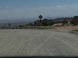
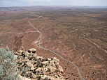
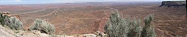
There's an infamous stretch of UT-216 between Natural Bridges & Goosenecks where the road seems to defy maps. This stretch of road is known as the Moki Dugway. The road drops over 1000ft in 2 miles as it descends, to the best of civil engineering's ability from the top of a mesa at 6000ft, to the valley floor, at 5000ft. This road has no guardrails, and sheer dropoffs, so if you aren't paying very close attention (particularly when you're on the outside edge), you'll likely go over the side. I had the pleasure of driving this stretch of gravel road twice. Once going up to Natural Bridges, and then again, down towards Goosenecks. On the first approach, we knew that we were close, because we had passed the 'warning' sign (above, first from left), but I couldn't figure out where it was, until it hit me that we were at the bottom when heading north, and therefore the huge 1200ft Cedar Mesa standing on the horizon in front of us was what we needed to climb. On the way back south, I knew what to expect, but going downhill on a 10% unpaved grade was still an interesting experience. Words really can't express how amazing the views are while driving the Moki Dugway (see above, 4th & 5th from left). The initial approach from the top was taken 2nd from left (above). Roughly a third of the way down, there was a good pulloff where I took the composite panorama at the very top of this page. About a half way down, there was a pulloff along side of one of the switchbacks, and we stopped to take the 3rd picture from the left above. Here's one additional composite panorama taken just below the top, with much of the entire valley (including Valley of the Gods towards the left side) spread out below:
::: {style="text-align: center;"}
 :::
:::
::: {style="text-align: center;"}
 :::
:::
::: {style="text-align: center;"}


 :::
:::
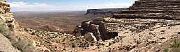
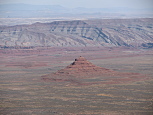
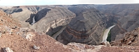
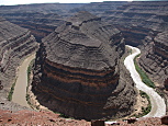
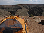
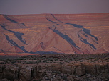
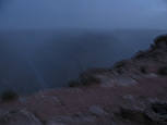
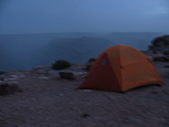
Goosenecks was amazing (composite panorama 2 rows above). The views in every direction were impressive to say the least. We could see Cedar Mesa to the north (above, first from left) where we had climbed & descended Moki Dugway earlier. Looking down into the goosenecks of the San Juan River (above, 2nd & 3rd from left), we could see the water rushing along about 1000ft below. The campsite was literally at the edge of the canyon (above, 4th from left). For some perspective, see above, 5th from left, where our tent is the tiny yellow speck in the upper right corner.
::: {style="text-align: center;"}


 :::
:::
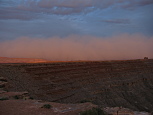
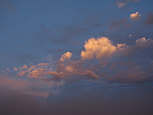
After setting up the tent, it was still nearly 100F outside, and we decided to head into the nearby town of Mexican Hat where we had a pretty good dinner at The Swinging Steak. Upon returning to the campground, we noticed that a storm front appeared to be moving in from the southwest. For a while, I was hoping that it would just pass to the south of us, and we'd be unaffected. However, as sunset approached, this storm was moving in faster & faster. The sunset itself was gorgeous (above, 1st row pictures). However, the storm was moving so quickly, that we were able to watch it enveloping the landscape to the south in real time (above, 1st row, 5th from left, and 2nd row, 1st, 2nd & 3rd from left). What was odd is that the clouds were hugging so close to the ground, almost like fog. But we were under the impression that there was no fog out in the desert, so we were really puzzled what was going on until it suddenly hit me that it might be a sandstorm. At that point, we started to get worried, and staked down the tent, and put on the rain fly, fearing for the worst. Within a few minutes, the storm started to cover the canyon, and the winds roared around us (above, 2nd row, 4th & 5th pictures from left). While it turned out not to be a sandstorm, it was a ferocious windstorm which started to blow sand up around us. We retreated into the tent, but that did little good. Even with the rain fly on the tent, wind & sand continued to get blown inside. Denise tried holding a bedsheet up against the screened door on her side of the tent, but all I had was a pillow sized towel, and the sand & wind continued to get blown through. As this was happening, the winds continued to increase in strength, and the tent started to shake & bend. To make matters worse, David was getting really scared, as the winds outside were howling and the tent was shaking all around us. After about an hour, the storm seemed to pass, and everything calmed down alot. After a quick survey, nearly everything inside the tent was coated with fine, powdery sand. We attempted to get it cleaned off as best as we could, but the sand was so fine, that it basically just clung to everything & hung in the air. At this point, the sky was mostly clear and we could see stars in nearly every direction, plus some mild light pollution from the nearby towns on the horizon. It was nearly 10PM, and we tried to go to sleep. However, within a few minutes, the winds started to pick up all over again, and either another storm or the tail end of the first passed through. The entire ordeal repeated all over again, although amazingly David managed to sleep through it all (as he got covered in a dusting of sand). After some debate, we agreed that we had to pack up the tent (and its contents), and retreat to the car for the remainder of the night. We had no way of knowing whether there would be more storms, and it was impossible to sleep (and becoming difficult to breath) with the wind & sand blowing everywhere. We cleared out the back seat of the car for David to sleep on, and Denise & I slept in the front seats. By the time everything was packed up, it was close to midnight. We slept poorly that night, but certainly better than if we had remained in the tent through additional storms. Denise commented that there was a 3rd storm a few hours later that actually shook the car. I managed to sleep through it.
All the pictures are posted here and here(landscapes).
This post is part 4 of the "southwest_us_trip-2009" series: