Southwest US trip - Day 2
This post is part 2 of the "southwest_us_trip-2009" series:
- Southwest US trip - Day 1
- Southwest US trip - Day 2
- Southwest US trip - Day 3
- Southwest US trip - Day 4
- Southwest US trip - Day 5
- Southwest US trip - Day 6
We awoke at sunrise, and proceeded to drive clear across Utah (I-15 -> I-70) to Arches National Park. After sitting in line for several minutes just to enter the park, we finally parked at the visitor center and attempted to purchase tickets for the Fiery Furnace ranger led tour for the following morning. Unfortunately, the tour was already booked up for the next 3 days. This actually ended up impacting our schedule & itinerary for the remainder of the trip. Our original plan was to take this 3 hour tour the following morning, and then drive to Mesa Verde National Park in Colorado the following afternoon, but instead we now had half a day free.
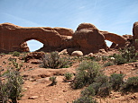
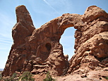
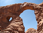
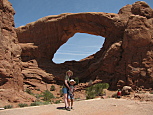
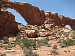
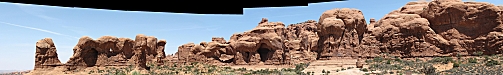
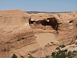
We started off by driving to "The Windows Section" of the park. As the name suggests, there are several huge mesas & buttes with large windows in them. We hiked the loop trail to start. At top is Double Arch and the Cove of Caves. Just above, from left to right, we saw North and South Window(1), approaching Turret Arch(2), Turret Arch(3), the South Window with Denise & David posing in front(4), and finally South & North Windows from behind(5). The hike took just under an hour, and there was some minor rock scrambling, but nothing too challenging. At this point it was still early afternoon, and we decided to continue north in the park to see Delicate Arch.
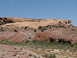
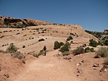
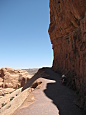

Delicate Arch has a distant view point that is car accessible, and also a 3 mile (roundtrip) strenuous (460ft elevation change) hiking trail that goes all the way to the arch. I opted to take the trail with David. From the trailhead, I knew that we'd have to climb a large expanse of slick rock (above, first and second from left), but I foolishly assumed that the arch was immediately at the top of that rock. Unfortunately, we were only about 2/3 of the way there by the time we got to the top of that rock. Following this was a maze of alternating sand pits and boulders which were exhausting. The final stage of the climb was a section of the trail that ran along a narrow cliff (above, third & 4th from left). The views were amazing, although it was a bit scary, since we were pretty exhausted at that point, and it was about 90F outside. However, just around the bend from the 4th picture (above from left) the arch came into view, and it was all worthwhile. The La Sal Mountains were visible in the distance, and the arch dwarfed all the people scrambling around it (above, 5th from left). We got a few more pictures in, and then headed back. The roundtrip hike took just over 2 hours.
It was now mid afternoon, and we needed to find a campground for the evening. We drove all the way out of the park with plans to stay in one of several BLM campgrounds that lined the Colorado River just east of the park boundary. Unfortunately, we neglected to take into account that it was a Friday evening, and that compounded with the fact that it was already late afternoon resulted in all 6 campgrounds completely full. After driving for nearly 2 hours, including a semi-creepy (Deliverance style) stretch on a USFS road through the Manti-La Sal National Forest, we ended up at the Moab KOA campground about 6 miles south of Moab. We had considered driving another \~50 miles south to Monticello to stay in a random motel, but the KOA was much closer, and coupled with the fact that we were exhausted and getting hungry, we sucked it up. The campground wasn't bad, but it wasn't worth \$30/night to get a 15x15ft square that bordered 3 other campsites. On one side was this family with 3 kids(all under the age of 10) who were running around hopped up on sugar until nearly 10PM. The other two sides were relatively quiet.

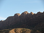
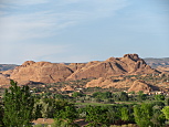
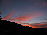
The views from the campground were actually pretty decent. From above, left to right, I saw the La Sal Mountains to the east, the mesa directly west of US-191, some random rocky hill to the north east, and finally, the lovely sunset.
All the pictures are posted here and here(landscapes).
This post is part 2 of the "southwest_us_trip-2009" series: