
Washington state
::: {style="text-align: center;"}
 :::
:::
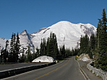
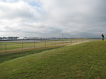
I spent the past week (mostly) camping in Washington state. The first day was consumed with the ridiculously long drive all the way up to southern Washington. I hate Oregon. I hate their crappy, unmaintained roads, I hate their selfish left-lane-loser drivers, I hate their lack of self-serve gas stations. Having to drive several hundred miles through their state increases my hatred. Thankfully, Washington doesn't suck, and we spent the first night at the Beaver Bay campground.
::: {style="text-align: center;"}
 :::
:::
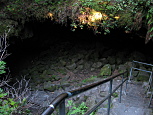
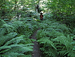
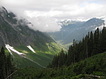
On Wednesday morning, we drove the 10 miles to the Ape Cave (btw, all the USFS roads in WA have good signage, screw you Oregon). We got there at 8AM, and other than the sound of chainsaws undoubtedly clear cutting a forest somewhere nearby, it was quiet, and we were the only ones there. The entrance to the cave is this long twisty staircase through a large, mossy hole in the ground. The cave is split between an 'upper' and 'lower' section. The upper section is 1.5 miles, and has an uneven floor, plus a lot of rocks and boulder scrambling. The lower section has a mostly smooth floor. We did the lower cave first, but after just a few minutes, david started freaking out that this wave of lava was about to show up behind us, boiling us
to death. Nothing that i said convinced him that we were safe. Eventually he shutup, but he was in a foul mood, and i gave up any hope of forcing him to do the twice as long, and much more challenging upper cave. The lower cave was still pretty cool. We were the only people in there, and without our headlamps, it was completely dark.
Also the cave wasn't straight, so we could never see more than a few dozen feet ahead. The ceiling was usually about 20ft high, and rounded, so it was fairly easy walking. There was a lot of water dripping from the ceiling, which david complained about as well. After we finished the lower cave (it dead ends, so we had to return
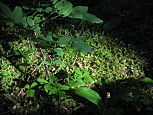
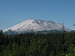
the way we came), and returned to the surface, I managed to convince david that we should hike the trail that leads to the exit of the upper cave. That trail was really nice. Tons of ferns and mossy draped pine trees, with trickling streams. At one point, we reached a clearing, and we could see much of Mt. St. Helens too. david perked
up a lot once he saw the volcano. We finished the trail, and got back in the car for the 50 mile drive to the eastern view point of Mt. St. Helens (Windy Ridge).
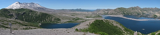
The drive there was a fairly mountainous forest road, and david complained nearly the entire time that he was car sick. The last few miles of the drive were amazing. Since the volcano's eruption (30 years ago) was mostly lateral to the east, we were literally driving through the blast and fallout area. There were still thousands of 30 year old trees knocked down all facing the same easterly direction that the blast took. On some of the less exposed hills, the dead trees were still standing. When we finally reached the viewpoint, it was mostly empty of people, although there were two park rangers hanging around just casually greeting people and answering questions. At that point we had an amazing view of the volcano, which still had quite a lot of snow on the summit. We also saw Spirit lake down below, which had hundreds of dead trees floating on its surface, dating back the 30 years. The lake doubled in size after the eruption as a result of all the ash and trees that were dumped into it. We had
lunch, and then hiked the 430 steps to the top of windy ridge, which is this 'small' hill behind the parking lot. From the top, the views were amazing. In addition to seeing the volcano, we also got views of Mt. Rainier (about 50 miles to the NE), Mt Adams (a dormant volcano, about 30 miles to the east), and Mt. Hood (about 70 miles south in
Oregon). David was in a pretty good mood at this point, cause he got to take in some 'views'. Also, we could clearly see little wisps of smoke rising from the top of the volcano, which david was both excited and a bit nervous about.
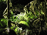
Next, we made the 2 hour drive up to Mt. Ranier, to find a campsite for the next 2 nights. The campground (White River) that we went to is the only one in the park that didn't require reservations, and also the smallest (112 sites). It was absolutely gorgeous. It had apparently only opened for the year, 2 weeks ago. There were streams from mountain snow runoff running all over the place. Some of the campsites were surrounded on both sides by a tiny stream. Others were surrounded by huge pine trees with thick hanging moss, and tons of ferns. We drove around for a bit, checking out all the sites, and eventually chose a site that was set up against a hill, with a stream running down it. David loved it. He spent most of his free time at the campground tossing random rocks and twigs into the stream. The southern edge of the campground was bordered by the White RIver, which is sourced by a few different glaciers on Mt. Rainier, so all of its flow (and it had HUGE fast rapids) had this milky color from all the silt. Additionally, we had a great view of Mt. Rainier, which is a huge mountain, with an obscene amount of snow. Also the campground had running, potable water, flush toilets, and fire pits. That night, the campground was less than half
full, and was super quiet. Also, because we were in this narrow river valley, with tons of really tall trees, it was incredibly dark. I actually went to bed before 8pm on Wednesday night, and slept fairly well.
::: {style="text-align: center;"}
 :::
:::
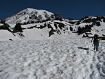
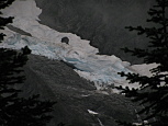
We woke up just after 6am on Thursday, and since all we had to do was eat breakfast, we got out in about 20 minutes. David wanted to go to the 'Sunrise' part of the park, which was only 10 miles away from the campground, and as its name suggests, provides clear views of the eastern side of the mountain, for sunrise. We did the drive, and david was fairly impressed with the views. Afterwords, we had a long drive to the other side of the park (the area known as 'Paradise') for the planned hike and other attractions. we got to paradise at 9am, and already the parking lot was mostly full. I'm not sure where all these people were, cause they were not on the trail, as there was no trail. It was under several feet of snow. However, some poor park ranger had been forced to hike out with several dozen tiny red flags to mark where the trail should have been, so we actually were able to follow a trail. This trail went up the side of the mountain. There was more snow than i've ever seen in my life. No trees, other than an occasional cluster, and just tiny red flags every few hundred feet as we hiked up the mountain. The views were amazing. David was having a ball drawing in the snow, tossing snow balls at me whenever i wasn't
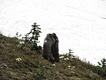
looking, and kicking snow. The one thing that we did see were tons of marmots. They were scurrying everywhere, and since there was snow everywhere, it was really easy to spot them. Most of them were forraging for food, but there were a few lazy ones that were literally just lying on rocks doing nothing at all, and a few that were
fighting. David thought it was hilarious. These furballs were rolling around, making squeaking noises. Also, we found this pretty big snow cave, with a river of runoff running out of it. It must have been at least 4ft tall at the entrance. We saw a bunch of marmots wander inside at one point. Eventually, the trail of flags appeared to lead right up an even steeper part of the mountain. One problem (of many) was that the actual trail that we were supposed to hike was supposed to fork off the main trail after about a mile, and the trail of red flags never forked. So i could only guess that they only bothered to mark off the primary trail, and none of the side trails. We decided at that point to turn back. Our feet were soaked, and kinda cold. We had lunch back at the parking lot, changed david's shoes & socks and then went to the visitor center. David got to watch the park movie, and checked out the exhibits.
::: {style="text-align: center;"}
 :::
:::
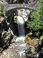
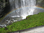
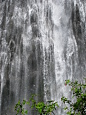
Next, we got back on the road, and stopped at two absolutely gorgeous waterfalls. The first (Christine Falls) was a series of cascading falls, that passed underneath the road. There was a hiking trail that went to a bridge over the top, and also went to the very bottom. The second (Narada Falls) waterfall was 168ft tall, and was amazing. Tons of mist drifting off (which david was thrilled to comment was nice & chilly), plus rainbows. Afterwords, we made the long drive back to the campground.
::: {style="text-align: center;"}
:::
We got up at 4:30 on Friday morning, because Google claimed that it could take up to 3.5 hours to make the drive to the Boeing Factory tour from the campground in Mt. Rainier. Unfortunately, it took only 2 hours, so we got there at 7am for the 9am tour. David was surprisingly patient as we waited in the car for almost 2 hours. The tour itself was incredibly boring. David was bored. I was bored. It was literally, going into the factory and looking at a bunch of mostly assembled airplanes. The problem is that it takes days to build an airplane, so its impossible to see any measurable progress just watching it for a few minutes. Also, the largest components are
actually manufactured elsewhere, and then assembled out here. The way that the tour is setup is absolutely horrible for anyone who isn't already intimately familiar with airplane terminology. They started with a brief film, but instead of actually putting something useful into the film to explain what we'd see on the tour, or even how
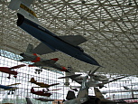
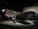
the different airplane models differ, it was all Boeing marketing fluff. \$25 wasted. After having lunch, we drove to the Museum of Flight, which was the complete opposite of the Boeing tour. This museum was amazing. Granted, its been about 10 years since i last went to the Air & Space Museum in DC, but from what I remember, this museum was nearly as good. There were literally hundreds of airplanes of all shapes & sizes, plus really well designed exhibits that explains aeronautical principles, how airports worked (different control jobs, terminology, etc), the history of aviation, special exhibits showing the evolution of WW1 & WW2 airplanes. There were also tons of movies. They had the original 747 prototype from 1969, one of the last remaining Concordes, the AirForce 1 jet that was used between 1965-1974, all open to explore fully. David had a good time, and i could have easily spent a full day there if i wasn't chasing david around.
::: {style="text-align: center;"}
 :::
:::
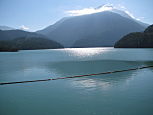
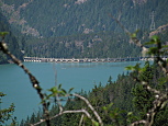
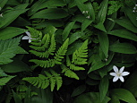
We got up on Saturday morning, and made the 2+ hour drive east out to North Cascades National Park. We spent much of the day in the Lake Diablo area. We got to drive across the Lake Diablo Dam, which excited david considerably. After that, we continued a bit further down the road to the Lake Diablo trailhead. The trail itself was quite nice, lots of ferns & moss early on, before we started climbing up the mountainside for expansive views of Lake Diablo. Afterwords, we backtracked a bit on the highway. We spent a little time looking at Gorge Creek Falls, and the park visitor center in Newhalem. We finished out the day with the 30 mile drive down the Cascade Pass road to our campground for that night, Mineral Park West. This was a gorgeous isolated campground deep in the forest, with the north fork of the Cascade River rushing beside it. The campground itself was semi-primitive with just 8 sites, a pit toilet, a few trash cans, and *no* running water. The only major problem was that the campground was infested with all manner of flying biting bugs (mostly mosquitoes). The bugs were just horrible, and we ended up retreating to the safety of the tent rather early that evening just to escape the biting.
::: {style="text-align: center;"}

 :::
:::
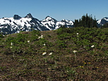
We awoke early (6AM) on Sunday morning, and made the 10 mile drive to the end of the road at the Cascade Pass trailhead. Just from the parking lot, the views were breathtaking. Steep, jagged peaks surrounded us on all sides, with tons of snow & glaciers near the summits, and all sorts of lush flora at the lower elevations. Thick fog hung just below the summits. As we were gathering our gear for the hike, we heard the roar of an avalanche (but didn't see it due to the fog). I was foolish for not making an effort to research the trail better in advance, and as a result, had no clue what it was like. I knew that we had some significant elevation gain (1700ft), but I assumed that it would be mostly evenly distributed along the full 3.7 miles of the trail. Instead it turned out that it was nothing but switchbacks for the first \~2 miles. And if that wasn't enough, they were switchbacks that kept crossing the same stream about 40 times. Eventually we got high enough that there were some amazing views, but I was so exhausted after the non-stop climbing that I wasn't able to finish the trail, and we turned back after just over 2 hours of hoofing it up hill. It was still a gorgeous hike, and perhaps some day I'll return to finish it with the knowledge that its rough for the first half, and then much easier for the 2nd.
Following that hike, we started driving towards home, and finished the drive the next day.