
New Zealand - March 1 - 9, 2011
Our flight to Auckland was expectedly lengthy, at nearly 12 hours. We landed just before 6AM, and had a full day ahead of us. First stop was to pick up the rental car, which went smoothly. We got a Hyundai Getz, and I proceeded to drive off down the left side of the road for the next week. Driving on the left was, interesting to say the least. I actually didn't have any major issues, but it always felt wrong. It didn't help at all that the turn signal & wind-shield wiper levers were on the opposite side from what I was accustomed. I lost count of the number of times that I turned on the wipers when I meant to signal left. Next we drove clear across the city, in rush hour traffic. This was actually a blessing in disguise, as the slow pace of traffic gave me ample time to get accustomed to driving on the left, not to mention turning into intersections.
::: {style="text-align: center;"}
 :::
:::
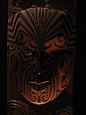
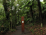
Auckland is a miserable city to navigate around. For reasons that are completely unclear, they rarely post street signs at most intersections, or they only post the minor cross streets. This resulted in us getting lost several times. Eventually, we found our way to the Auckland War Memorial Museum. The museum is situated at the top of a hill in the middle of a really scenic park. The museum itself is really nicely done. It has 3 floors of exhibits covering Maori art, Auckland history, South Pacific island culture, natural history and New Zealander war sacrfices.
::: {style="text-align: center;"}
 :::
:::
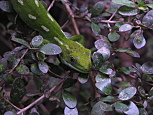
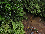
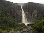
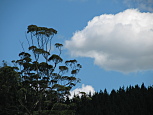
The second day, we awoke early, and hit the road, heading south, out of Auckland. Our goal for that night was to stay just west of Tongariro National Park for a hike the following day, however before that, we wanted to stop at Bridal Veil Falls, about half way there. To get to the falls, we drove for over an hour on a maze of back roads. Initially, the scenery was rolling farm land, which Denise commented reminded her a lot of south western Pennsylvania. After a while, the terrain started to change, and we passed through old growth forest, which was a cross between tropical jungle and temperate rain forest. Kind of a Hawaii meets Olympic peninsula Washington state. It was gorgeous. Finally we reached the (p)reserve where the falls were, and we had a short hike through the lush, verdant forest to the upper viewing platform of the falls. The forest was absolutely gorgeous. Ferns and palms everywhere, plus a muddy river slowly meandering beneath the canopy. The falls were also amazing. The upper viewing platform sat just beside the top of the falls, overlooking the valley below. From there, we walked down the mountain to the middle viewing platform where we saw the entire falls, which were huge. Then it was down to the bottom of the valley, where we were at the base of the falls. Again, gorgeous. As we're hiking back up the mountain to the car, David spots an animal not far from the trail, which turns out to be this white goat, calmly munching on assorted vegetation. I do my best to fire of a few shots, before it decides that I've come close enough, and it scrambles off. As we return the car, the cloudy skies open up, and it starts raining. Not too hard, but enough to make things unpleasant.
It rains off & on for the remainder of the afternoon. By the time we reach the hotel that night, its no longer raining, however, its still overcast. We inquire about the weather forecast for the next day at the park visitor center, where we learn that its supposed to rain for much of the next 24 hours, quite hard (or "heavy falls" as they say in NZ). This about squashes my hope of hiking the the Tongariro crossing, the famous \~12 mile trail that runs past two not-extinct volcanoes. According to the park ranger, there are currently \~40MPH winds at the trail head, not to mention fog, and heavy rain. This hike was prolly what I was most looking forward to, and its clearly not going to happen. We scramble to look for an alternative hike that won't turn into a suicide mission if its pouring rain, with wind & fog, and find a 6km trail at a much lower elevation, the Taranaki Falls trail. When we went to bed that night, it wasn't raining, so I held out a small hope that the weather would be better in the morning.
::: {style="text-align: center;"}
 :::
:::
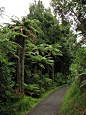
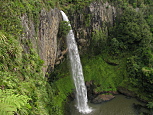
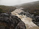
When we awoke the next morning, it was pouring rain again. Harder than the day before. We got breakfast, and drove the 10 miles to the trailhead. Unsurprisingly, there was no one else at the trailhead. The crazy folks were likely up at the Tongariro crossing braving the gale force winds, and everyone else was sleeping. We suited up in our rain gear, and headed off down the trail. The trail was in surprisingly good condition. I give a lot of credit to the park staff for building a trail meant to survive storms and copious runoff. While there were occasional puddles, it was otherwise in decent shape, and we made good time. The first third of the trail was relatively flat, and exposed, with low shrubs. As we got closer to the waterfall, we crossed a few bridges, and there were a few short hills to climb. All of the river crossing were flowing fast & furious, with a lot of mud & rocks. The falls were huge, and for lack of a better word, angry, making this loud roaring. It was a rather awesome sight. More than half of the hike back was in a dense forest, full of tall conifers and pretty ferns of all shapes & sizes. We got back to the car in just under 2 hours from the start, and we were rather soaked. If I hadn't been moving at a fairly brisk pace, I likely would have gotten cold, but my body heat kept me warm enough. We changed clothes in the park visitor center, and drove north east towards Rotorua.
::: {style="text-align: center;"}
 :::
:::
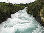
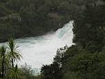
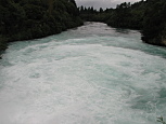
Along the way, we stopped at Huka Falls, which was more of rushing rapids than a waterfall. Even so, it was impressive, if a bit touristy. The next day we were supposed to take a boat to an offshore active volcano, White Island. Unfortunately, when I called to confirm the reservation, they had canceled the boat due to the high seas from the storms. Denise was very disappointed, as this was the activity that she was most looking forward to, and was easily #2 on my list. After some scrambling we decided to spend the next driving out to Te Urewera National Park to check out a nice cluster of waterfalls near the visitor center. It looked like a nice drive, and we were also considering to explore up or down the east coast afterwords depending on how the time went.
We headed out the following morning, and initially made really good time. Then we passed a sign referring to 95km of 'unsealed' road ahead. We were initially confused what they were referring to, until the pavement ended. We spent the next 2.5 hours bumping along on rutted gravel & mud, over jungle mountain passes. There were cows, pigs & chickens wandering along & across the road on occasion. While it was all gorgeous, it wasn't much fun to drive, and took substantially longer than we had planned. It was early afternoon by the time we got to the visitor center. We got out to look around a bit, but as we still had about 20km of 'unsealed' road ahead, we didn't have time to explore. We got to the coast and decided to head south towards Napier. We had read that after an 1931 earthquake, the entire town was destroyed, and was rebuilt entirely in an Art Deco style. After driving for another hour, we got to Napier. It was rather disappointing. While there were a number of Art Deco buildings, overall, they were run down, and most of the buildings were the vanilla modern commercialized stuff that we'd find just about anywhere. We then had a two hour drive back to Rotorua (on a paved road). As we got closer, the sky started to clear, and we saw a few rainbows.
::: {style="text-align: center;"}
 :::
:::
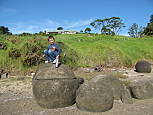
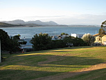
When we woke the next morning, the sky was clear, and it was sunny for the first time since we arrived in NZ. We had a long drive ahead of us that day, all the way up to the north end of the island. The drive went fairly smoothly, and once we crested the hill over Hakianga Harbor, the view was amazing. We then headed off to the bungalow that we were staying in for the night. It, too was amazing, overlooking the bay. After getting settled in, we drove down the road a bit to check out Koutu Beach, and the boulders. The beach is littered with huge unusually spherical boulders, not to mention a ton of assorted sea shells, and a few random (dead) jellyfish. It was a nice walk, in gorgeous weather.
::: {style="text-align: center;"}
 :::
:::
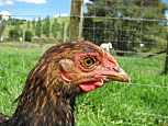
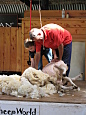
The next day the great weather continued, and we drove south back towards Auckland. About an hour north of Auckland, we stopped at Sheepworld. It was a cross between petting zoo, and promotional fair for the wool industry. Even so, there was one really awesome aspect, where they did a full demonstration of sheep dog herding plus sheering, which I was quite impressed with. David even got to help with the sheering. Afterwards, he bottle fed a piglet which thrilled him quite a bit.
::: {style="text-align: center;"}
 :::
:::
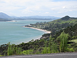
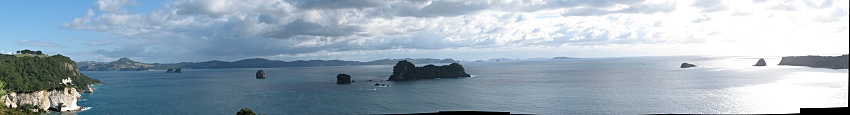
On our last day in country, we drove south east of Auckland to the Coromandel Peninsula. We wanted to explore some of the beaches and coast. It was again, gorgeous. We stopped first at Gemstone Bay, where there were tons of pretty islands scattered about. Next we drove a bit south to Hot Water Beach. Unfortunately, the tide was coming in, so we couldn't explore too far, but David still had a great time.
The flight back that night was uneventful. It was a nice trip. Pretty low on the stress front (other than the day of 95km off pavement), with gorgeous scenery, and nice food.
All the pictures are posted here.