
New Mexico
We just returned from our big camping trip of the year, 10 days travelling around New Mexico (July 4 - July 13). Overall we had a great time, and did/saw everything that we had planned. If I had any complaints, its the stupid monsoons. When I read comments and warnings about the summer time monsoons in Arizona & New Mexico, I assumed that it was an occasional thing. In reality, it really meant that on any given day, nearly the entire state would experience a big thunderstorm at some point in time (often in the early evening). We experienced thunderstorms all 10 days, with actual rain getting dumped on us, nine of those days. Much of the time, the storms were merely a mild annoyance, but on two days (more on this below), they were a pretty miserable experience.
<p>
<center>
</center>
</p>
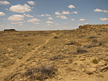
Our first day was a long, long drive of nearly 830 miles from our home all the way out to Tuscon, Arizona. Overall, the drive was fine, but I should have known something was brewing when it was foggy while driving through Los Angeles, then overcast while crossing the desert of southeast California, and finally thunderstorms for much of Arizona. Even so, we managed to pull into the campground just west of Tuscon around 4PM (12 hours of driving). Oddly, the 200+ site campground was almost completely empty. We were the only people in the loop, and I only saw two other vehicles in another loop. Sure, Arizona is hot in the summer, but it wasn't that hot. This was to become a trend, as nearly every campground we stayed in was less than half full.
<p>
<center>

</center>
</p>
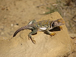
The next day the sun was shining brightly, and we continued to drive eastward. Our first stop of the day was the White Sands Missile Range museum/park, less than an hour northeast of Las Cruces, New Mexico. This was quite the gem, with over 50 real (decommissioned) missiles of all sizes on display outside, plus a museum covering the history and impact of the missile range. David loved the outdoor displays, and I liked the museum. It was definitely an easy hour well spent.
Afterwards, we backtracked a bit through Las Cruces, through some miserable construction at the I-25/I-40 interchange, and eastwards towards Carlsbad Caverns. Due to peculiarities of the road system in southeastern New Mexico, the only way to get to the caverns from the west is through (El Paso) Texas. I had been to El Paso over 20 years ago, and what little that I remembered was that it was rather ugly, crowded city. Sadly, little has changed. Even though I attempted to loop around the northern & eastern outskirts of the city, it was still an ugly mess. Nothing but endless run down strip malls, shanty towns, congested streets and slums. Once we got out of the city, the scenery definitely improved dramatically, and we were making good time. Of course no trip to a southern border state is complete without being subjected to a US Border Patrol inspection station, and this was no exception. I felt so much more safe & secure knowing that being quizzed for 5 seconds about my origin & planned destination, with no effort to actually look inside my vehicle, kept the dreaded illegal aliens at bay.
I didn't have a definitive idea of where we would camp that night, as the options near the park weren't that great, and the park itself had no campground. First we tried looking for a 'free' primitive (AKA, no facilities at all, just open land) BLM campground a few miles south of the park. I followed this road for a few miles, as it slowly degraded into a rutted, rocky mess. After nearly 3 miles of this, I decided this was going to be a mistake, so we turned back. We ended up staying in the Whites City Resort campground, for the princely sum of \$22.50/night (we stayed two nights). Calling this place a resort is the same as referring to McDonalds as fine dining. There was nothing wrong with the campground, but at the same time, it wasn't significantly better than most free or very inexpensive campgrounds that we've stayed in elsewhere. My only big complaint is that they claimed to have free wifi, but the only part of the campground where there was any signal was of course the opposite end from our campsite, and even there, it was very slow, and the connection dropped out every few minutes. This turned out to be the day with the first of two very bad thunderstorms. As I was preparing dinner, I noticed the skies to the east darkening quickly, and it wasn't long before we heard a lot of thunder, and saw lightening bolts. Before the rain started, came the wind, which was literally blowing the tent sideways. Before I had even finished making dinner, the sky opened up, and down came both rain & hail. Coupled with the high winds, and the precipitation was blowing horizontally more than vertically. I turned off the stove, and we both ran to the car. Within minutes the ground throughout the campground started to flood with standing water. As we sat in the car praying that our tent wouldn't blow away, someone from the the resort office came by to warn us not to try to drive out of the campground, because the 'road' leading into the campground was currently under a foot of flowing water. After about a half hour, the storm started to pass, and I checked to see what could be salvaged of dinner. The stove itself had almost an inch of water sitting in it, and wouldn't light. The food that I had made was mostly cooked, but wasn't all that warm any longer. We ate what was there, but it wasn't all that appetizing. Thankfully the tent was still there, but the wind & rain managed to flood the inside of the tent. It was a fairly miserable soggy night.
<p>
<center>
</center>
</p>
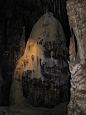
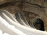
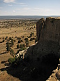
We awoke the next morning to clear skies, and drove the 7 miles into the park. The way the park is setup, the visitor center (and the primary cave entrances) are all at the top of a mesa, which overlooks the rest of eastern New Mexico, and onward into Texas. As such, the views were absolutely amazing, with flat plains stretching out to the horizon in all directions. Our plans for the day were to do the Slaughter Canyon Cave tour, and then afterwards, do the self-guided Carlsbad Caverns natural entrance tour later in the afternoon. We met the rangers doing the Slaughter Canyon Cave tour (hereafter known as SCCT) at 8:30AM, and they did some brief orientation. This tour is one of three special, advanced reservation, extra fee based "adventure" tours that are offered. It is limited to a total of 15 people, plus two ranger guides. SCC is not a tourist cave, it has no artificial lighting, no signage, and very few railings or guidance. If you got lost inside the cave without both a light source and a very good sense of direction, you'd likely never find your way out. The two rangers conducting the tour distributed hard hats with head lamps to everyone, and then we drove about an hour out to the cave parking lot (which is several miles south of the main park entrance). The hike started by hiking about a half mile (with 500ft elevation gain) up the side of the canyon to the cave entrance. While the rangers warned everyone that this was a strenuous climb, I honestly didn't find it all that difficult. While it certainly wasn't easy, I've done many other hikes which were far more challenging. I'd say about half the people there looked like they were going to die, and the other half found it easy. Once inside, everyone put on their helmets, and turned on their head lamps, and we started the actual tour. Overall, it was a really nice, enjoyable tour. The rangers did a great job noting special points of interest in the cave, plus giving a lot of information about the cave's history (natural & man made). We spent about two hours inside the cave, including several minutes where everyone was asked to turn off their headlamps, as we sat in complete darkness just to see what it was like. Upon exiting the cave, it had been raining. Everyone had to then hike back down the mountain on a fairly wet & muddy trail, and shortly before returning to the car, the storm picked up again, and it started raining even harder. Once back at the car, we returned the cave gear to the ranger, and drove back up to the visitor center area of the park. We then proceeded to hike down via the natural entrance into Carlsbad Caverns itself. This is a very tourist friendly cave. The floor is paved everywhere, there are lights all over the place, lots of signage, and even a cafe at the lowest level of the cave. None of this is to say that it wasn't a nice cave experience, but it was vastly different than the SCCT from earlier in the day. What did make this cave fun, is that its a very deep cave, and the walkway was comprised of many switchbacks and spirals that made it feel like we were descending much further than the (roughly) 8 stories that we walked to the lowest level. I didn't feel like any of the formations were anything too special or unique. Its definitely the size of the cave that is the main attraction rather than the formations. Once at the bottom level, we had a choice between taking an elevator all the way back to the top (with a \~50 minute wait in line), or to walk all the way back up the way we came. There were several scary signs warning how difficult/strenuous & time consuming walking back up to the natural entrance would be. Plus a warning that they locked the natural entrance at 5PM, so anyone still in there was required to take the elevator if they didn't start hiking back up no later than 3PM. It was currently a little after 2PM, and when faced with waiting in the elevator line for an hour+, we decided to suck it up, and hike back up. While I could certainly understand what would make this a tough hike back up, the cave is 60F, which is a great temperature for strenuous exercise. So while I was definitely breathing hard, I never felt all that hot. Despite the "you will need about 2 hours to hike up" warnings, we did the entire thing in about 45 minutes. All I can say is that most Americans are obese lazy slobs, if they can't do this in under an hour. Once back at the surface, we drove back down to the campground to rest.
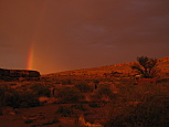
We were hoping to go to the evening Bat Flight program at 7:45PM, where hundreds of thousands of bats emerge from the cave to hunt insects. However, this depended on how the weather cooperated. As the afternoon progressed, I saw the dreaded dark clouds looming off on the eastern horizon once again. I made dinner, and the storm hadn't yet reached us, even though I could hear the thunder rumbling in the distance. Oddly, by the time we needed to drive back into the park for the bat program, the storm had still not reached us, so we headed back up. The program takes place in a stone amphitheater surrounding the cave's natural entrance. We arrived about an hour early, and the place was already a zoo, with half the \~250 seats occupied, and random rowdy kids running everywhere. Looking in the distance was the same storm, which seemed to be moving in a slightly different direction. Eventually a really nice rainbow appeared just above the cave, and I was cautiously optimistic that the storm had veered off in another direction. Eventually a ranger started talking, giving random facts about the bats, mostly just trying to kill time before they emerged. Then the bats started to fly out. It looked like a tornado of bats, as they flew out of the cave in a very tight spiral, and then veered in unison to the south. It was quite the impressive sight, as the bats just kept coming and coming out of the cave for minutes. After about 20 minutes, the number of bats started to dwindle, and people started to head to their cars. As we drove back down out of the park, the storm opened up, and the rain arrived. Thankfully it let up after a few minutes, and the rest of the night was dry.
<p>
<center>
</center>
</p>
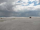
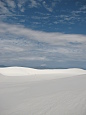
We awoke the next morning to clear skies, packed up camp, and proceeded to drive northwest. We arrived at White Sands National Monument at mid-morning. This was quite the surreal sight, with huge bright white sand dunes stretching on for miles. They looked a lot like huge mounds of snow, especially when they drifted onto the park road. Of course it was almost 90F, and with an ominous dark storm hovering near the mountain range to the east, it was definitely not a snow day. We opted to do a loop hike over the northwest corner of the park. It was fun for a while, but hiking up & down tall sand dunes is quite the workout, and in the heat, it started to become a death march. Even so, we made it far enough out into the dune field that we couldn't see anything but more dunes in all directions, which was quite the sight. We got back to the car by late morning, and started driving north.
<p>
<center>
</center>
</p>
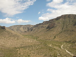
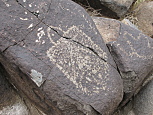
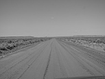
A few hours later, we arrived at Three Rivers Petroglyph Site, which is a BLM managed hill, with several hundred recently discovered petroglyphs dating back over 600 years. On queue as we arrived, a thunderstorm was rumbling just a few miles to the south. We started hiking up the hill, and quickly spotted numerous cute, interesting or completely bizarre petroglyphs. About half way up the hill, it started to rain, and thunder & lightening were firing all around us. We decided it wasn't worth getting electrocuted just to see the rock art, so we headed back to the car. Even so, we easily saw several dozen petroglyphs. The original plan for the day was to camp several miles further up the road in a USFS campground, however as we drove in, we saw a huge red "CLOSED" sign plastered beside the campground signs. I had no other ideas of where to camp in the area, and the next campground that I knew of was a good 3 hour drive northwest. I figured I'd start driving in that direction, and hopefully find some other decent campground enroute. Of course, fate conspired against me. After driving about 15 miles further north, I entered a construction zone, and spotted a sign warning that there was a temporary traffic light ahead to control single lane traffic. Shortly thereafter, all traffic came to a stop, and I sat on a hill, behind a truck. I figured it would be a few minutes, and then we'd be moving. We waited 15 minutes, with a torrential downpour outside. Then 20, then 30, then 40, then 50. There was no indication what was going on, nor were there any cars travelling in the opposite direction. I got out of the car hoping that if I walked up a bit, it would be obvious what was going on. Except that all I saw was a hill that kept going, and the traffic backed up the entire way. Behind us was easily another 30+ cars. It was nearly 2:30PM (nearly an hour since we were stopped), and I potentially had another 3 hours of driving ahead of me. I looked at a few maps, and decided that I could make a longish detour to get where I needed to be. I made a u-turn, and drove. In hindsight, this detour was almost definitely not any faster, but at least I was moving somewhere. This detour ended up taking me through silly mountain resort towns, with tons of weekend traffic, curvy mountainous roads, and ridiculously low Indian reservation speed limits. Nearly two hours later, I got to the point that ended the detour, and was finally making real progress. Of course we didn't pass a single decent campground the rest of the way, and finally pulled into a campground just after 6PM.
<p>
<center>
</center>
</p>
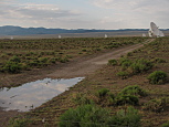
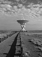
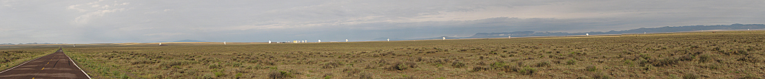
On queue, the rain & thunder started just as we got out of the car. David raced to setup the tent, while I worked on dinner. Thankfully, the picnic bench was actually covered in this campground, so the rain didn't cause much of a problem. It continued to come down off & on for much of the night, but thankfully there weren't any strong winds, so the tent was dry inside. When we awoke the next morning, it was surprisingly not sunny, and everything outside was still very wet and cool. I packed up the tent, but it was a muddy mess outside. The good news is that we were only about 15 miles away from our first stop for the day, the Very Large Array(VLA). The VLA is comprised of 27 HUGE satellite dish antennas, arranged in a Y formation across a wide, remote valley in western New Mexico. Its been filmed in several movies, including Contact, back in 1997. The site is quite impressive. The dishes are larger than most people's homes. There's an excellent self-guided walking tour of the site, with numerous signs explaining everything in a very understandable way. Additionally the visitor center includes a 9 minute film that further explains the purpose of the VLA. Since we arrived at 8AM, we had the entire site entirely to ourselves, which was awesome on many levels.
<p>
<center>

</center>
</p>
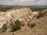
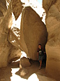
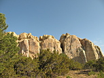
Next, we proceeded to drive northeast, towards Albuquerque, to Kasha-Katuwe Tent Rocks National Monument. This was another BLM managed site, which is very poorly promoted. The site is comprised of numerous volcanic ash pillars, with much harder rock caps. As a result, they appear like very tall tents. The site is quite stunning, and I suppose its a good thing that not many people know of its existence, or it would likely be overrun with hikers & tourists. We arrived at mid day, and hiked all of both trails. The first is a loop which meanders through a pinyon pine forest, with the towering tent rocks not too far off in the distance. The second trail starts at the half way point of the first loop, and shoots directly into the heart of the formations. A large chunk of that trail is an awesome slot canyon, and then it starts to climb steeply to the top of the mesa, providing incredible views over the formations from above. While it was quite warm while we were there, the hiking was superb, and we enjoyed it a lot. Afterwards, we continued north to Santa Fe, where we spent the night.
<p>
<center>
</center>
</p>
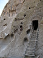
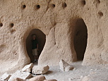
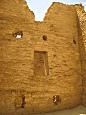
The following morning, we headed northwest into the mountains, and Bandelier National Monument. The park's primary focus are dozens of cliff and canyon cave residences dating back over 500 years. Our first stop was at the campground, to secure a site for that night. Since it was only an hours drive from Santa Fe to the park, we arrived at the campground just after 8AM. We got some rather strange looks from people were still packing up their camps from the previous night. Since Bandelier restricts all access to the interior of the park via a shuttle bus, which was over a mile walk from our campsite, we opted to hike into the park. The Frey trail is a 1.6 mile hike down into Frijoles Canyon. Prior to the park road being developed back in the 1930s, this trail was the only way into the park for all visitors. Since it was still cool, and all downhill, it was a rather easy hike, with some rather nice views. The trail ended at about the half way point of the main loop trail (which winds its way past all the excavated archaeological sites on the canyon floor). Many of these sites have ladders allowing anyone to go inside and explore. David loved this stuff, and was quite eager to explore all of them. I checked out the first one that we passed, but all the sites were rather cramped, with ceilings less than 5ft tall. After finishing one side of the loop, and spending some time at the visitor center, we worked on the other half of the loop. At the far end of the other side of the loop is a turn off for Alcove House. The trail to Alcove House is flat, and easy. The route *up* to Alcove House, is just plain crazy. Four ladders climbing 140 feet above the valley floor. David loved it, I wasn't too crazy about the climb up. Once at the top, the alcove itself was nice, although we started to hear thunder in the distance. The house even had a kiva, with yet another ladder leading inside, that David was compelled to climb up & down 4 times. Going down however, was not at all fun. I hate heights. As hard as I tried, the climb down was rough. I was holding on tight the entire way. The last hike of the day was the Falls trail. This one was really nice. It started off in the woods, following a creek. As we continued the creek descended into a narrow rocky canyon. Towards the end, we rounded a bend, and the Rio Grande valley opened up in front of us, and then after another bend, we saw the water fall deep below us. We headed back to the visitor center, and took the shuttle up to the campground. As we walked the mile back to the campsite, we kept hearing more thunder, and the sky was starting to cloud over. We figured that we were going to get dumped on soon, so we held off on building the tent. Oddly, the rain never came. There was a lot of thunder, some distant lightening, but it never rained.
<p>
<center>
</center>
</p>
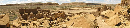
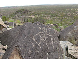
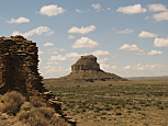
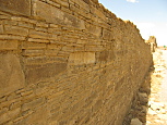
When we awoke the next morning, the sky was clear, and we headed towards Chaco Culture National Historical Park. This park was full of the classic southwest scenery. Buttes, mesas, and ancient Pueblos over a thousand years old. We grabbed a campsite, in the especially scenic campground, and then headed off for a brief stop at the visitor center. After that, we hiked the short Una Vida trail, which included some ruins and a few petroglyphs. Next, we stopped at each of the sites along the northern half of the park loop road. Each of them had really awesome ruins, and great views. Eventually we reached the Pueblo Alto trailhead. This trail was absolutely amazing. It was a 5.4 mile loop, up and around a huge mesa. To get up there, we had to scramble up rocks in a very narrow slot canyon. Once at the top, the trail was mostly just following many, many cairns. For a while it followed very near the edge of the mesa, but soon swerved inward to a set of amazing ruins. Scattered amongst the ruins, on top of this mesa, were many small pottery shards, at least a thousand years old. All the while that we were up there, we could see for many miles in all directions. There were buttes near & far, other mesas, distant dirt roads leading across the desert. We saw a total of 5 people the entire time we were up there. About half way through the trail, as we were very gradually starting to descend, we came to yet another slot canyon, but this one was far more narrow the one one that we took to the top. I literally had to go down sideways, because it wasn't wide enough to squeeze through facing forward. Eventually we made it back to the trail head (after descending the same slot canyon that we had to climb originally). This trail was definitely my favorite hike of the entire trip, and that's not because the other hikes weren't great, but because this one was absolutely amazing. Following the hike, we returned to the campground to rest. On queue as I was preparing dinner, storm clouds were massing to the north. We finished dinner, and the wind started to pick up, and then the thunder, lightening & rain. We went into the car, hoping to ride out the storm. It blew through in about an hour, and in its wake, we were treated to a huge rainbow as the sun illuminated the canyon walls. As the storm crossed over the valley, we were treated to an amazing lightening show, as sky to ground bolts were firing all around the largest butte. The next morning, we got up early, and headed out to hike the 7 mile Penasco Blanco trail. Due to the storm the previous day, the trail was a muddy mess. It was still nice, as we passed a section with numerous petroglyphs. Towards the end of the trail there was supposed to be a petroglyph site where the Chacoans documented a supernova back in the year 1057. Unfortunately, this section required a stream crossing, which was flowing too deep & fast for us to safely cross. As a result, we had to turn back. After stopping at the visitor center to watch the 30 minute park movie, and eating lunch, we decided to do the 3.2 mile Wijiji trail. This was a relatively short & easy trail, leading from the campground to the east. It ended at another set of ruins, and some nice petroglyphs and hand print rock art. It was really cool to see the hand prints of people from over a thousand years ago. That night, after we had retired to the tent, the worst storm of the entire trip ripped through the area. The first wave was very strong winds, and a little rain. The second wave was mostly thunder & lightening. However, the 3rd wave, which didn't arrive until nearly 10PM, was rain, thunder, wind & lightening, and flooded the tent. Worse, it was very slow moving, so the rain kept getting blown into the tent for over an hour. Once it finally past, another band of rain came through around midnight. By morning much of the inside of the tent was still very damp.
<p>
<center>
</center>
</p>
After packing up the wet mess of the tent, we attempted to leave the park from the southern access road. Chaco is somewhat unique, as all the roads leading to/from the park are unpaved, even though the roads inside the park are paved. After the strong storm the night before, I was very concerned that the road out would be in very poor condition, either very muddy, or possibly even washed out. Thankfully, the road was passable, although a few portions were rather muddy. We drove south for a few hours, and arrived at El Morro National Monument just before it opened at 9AM. What made this park special is the tall rocky bluff, which travellers over the past 4 centuries have stopped at for its watering hole. While there, many of them have carved their names into the base of the rock. As a result, the names and dates of people dating as far back as Spanish explorers in 1609 are present. What I found fascinating is the different styles of "handwriting" used by people over time. Many of the Spanish explorers used this very ornate fancy script. The American settlers had a very formal print. Eventually the trail climbed the side of the rock to the top, where we were treated to awesome views in all directions. The 2 mile loop took us just under two hours, and was quite enjoyable. Afterwards, we drove further west into Arizona (and through yet another thunder storm). Nearly half the drive on the final day was through yet more thunder storms in the desert.
<p>
<center>
</center>
</p>
Overall, it was a great trip. It would have been nice if there were fewer storms, but that didn't detract from the great things that we did & saw.
All of the trip pictures are posted HERE.
<p>
<center>
</center>
</p>