Nevada
Since moving to California over 13 years ago, we've travelled fairly extensively throughout the western US, camping in nearly every state. The only exception was Nevada. While we've done a few trips in and around Las Vegas, and driven across the state a few times, we never saw much of it, and never camped there at all. I've been itching to checkout Great Basin National Park in far eastern central Nevada for a while, and wanderlust got the better of me, and we planned a trip out there. We spent six days working our way east from California.
<p>
<center>
</center>
</p>
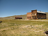
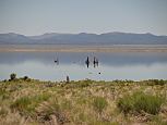
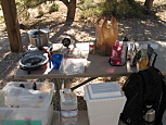
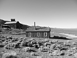
The first day, we got up early, and headed due east for the eastern Sierra. After a slow, yet gorgeous crossing over Sonora Pass, we headed out to Bopdie State Historic Park, which is one of the most exceptionally well preserved ghost towns in the entire country. Due to its relatively dry, isolated location, the buildings have survived well over one hundred years in excellent condition. The road up to the town is about 13 miles, with the first 10 paved, then its a fairly smooth rock & gravel the rest of the way. I expected the town to be mostly empty, but its become quite the tourist attraction, with several dozen cars already parked at 10AM. The town itself still has several dozen buildings standing, most of which are clustered in a tidy grid, but there are a few that are further out. Very few of the buildings are open to explore, but for most we were able to look through the windows to see common items ranging from pictures to dining utensils to feather beds. While it would have easily taken several hours to explore every building, after a while its obvious that many are quite similar. We spent just over an hour, and then headed back out, and back to US-395. The next stop was the south shore of the ancient Lake Mono. David & I had actually visited this very same spot nearly eight years ago, although he claimed not to remember any of it. The lake was still nice, although it was obvious that the water level had dropped even further over the past 8 years. Whether this was just the continuing passage of time, or the more recent severe drought wasn't clear. Afterwards, we headed back up and around the lake, towards Nevada. The original plan was to spend the night camping along the western shore of Walker Lake. When we first arrived, we found one lonely man sitting at a campsite, and the rest of the area was completely empty. At first, this seemed awesome, as we'd have a peaceful evening. However, as we slowly drove around, we noticed that every man made object was covered with spider webs and huge orb weaver spiders. The campground was completely infested, horror movie style. We promptly decided that we wouldn't be comfortable spending any time there, and headed eastward in search of a more hospitable campground. Our plans for the following morning were to drive out to Berlin–Ichthyosaur State Park. Some quick searching of that park's website showed that they also had a campground. Our goal was to drive the 77 miles, and hopefully spend the night there. The drive out was uneventful, through fairly empty, lonely roads. We passed, maybe, 5 cars during the drive. However, once we got there, we found a mostly empty campground, in much more pleasant surroundings. No spiders, and at a much higher elevation (around 7000ft.) made for cooler temperatures, with trees. Denise made tasty tacos for dinner, and we enjoyed a peaceful evening. That night the sky was full of amazing constellations, including the milky way.
<p>
<center>


</center>
</p>
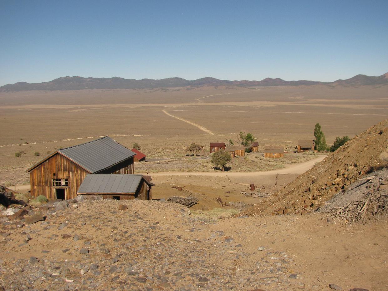
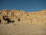
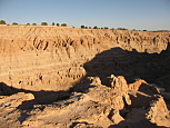
We awoke at sunrise (which is unfortunately around 5AM this time of year), ate breakfast, packed up camp, and drove down the hill to the Ichthyosaur exhibit which gives the park its name. Ichthyosaurs were marine dinosaurs, which kind of looked like a cross between a dolphin and a whale. The park has fossils from at least two of them, protected inside a building. While they do offer a few tours each day during the non-winter months, its still possible to view the fossil dig site through large windows. To be honest, had we not known we were looking at fossils, we never would have guessed that there was anything there at all. Much of the skeleton was still buried in dirt, and what little was visible looked mostly like randomly shaped rocks. It was still kind nifty to see a dinosaur skeleton, but likely not worth the long drive up there. However, the second half of the park name (Berlin) referred to the old mining era ghost town, which still had several well preserved buildings, plus open mines, and many random artefacts scattered about. It was nice to explore the area, without any other tourists about. Next we had about a two hour drive south towards the town of Tonopah, to explore the Tonopah Historic Mining Park. Tonopah was founded as a mining camp over a hundred years ago, and up until the middle of the 20th century, ran some of the largest scale mining operations in the western US. The park itself was situated on the grounds of several of those mines, and included a lot of the mining equipment and buildings from that era. Overall it was nice, although somewhat confusing to explore. The signs were rather limited, and the park map/brochure didn't make it entirely clear how to walk between the major points of interest. While it might have been feasible to spend at least half a day there, the oppressive summer heat didn't quite motivate us to see much more than the major points of interest within a short radius of the visitor center. As we were now several hours ahead of schedule for the day, it didn't make much sense to attempt to go to the planned campsite for the day just after lunch time. We decided to make the 3.5 hour drive east all the way across Nevada, to Cathedral Gorge State Park, which was supposed to be our planned stopping point the following morning. We got out there by mid afternoon, to find the campground nearly empty, and temperatures nearly 100F. We had definitely moved from the higher & cooler elevations to a low, dry, windy & hot desert. After having pasta for dinner, we headed out to go hiking a bit. As the sun was getting lower in the sky, it wasn't quite as hot, and the light was gorgeous. We walked to the east side of the park, where David & I picked up the Miller Point trail. It started off in a wash, with steep redish hued canyon walls, very similar to Bryce Canyon. Eventually we came upon an uneven staircase, which took us up to the cliffs above, for an amazing view of much of the park, with the sun setting. On the way back, we explored the Cathedral caves (a few short, narrow slot canyons), and a CCC era stone cylindrical water tower, before heading back to the campground.
<p>
<center>
</center>
</p>
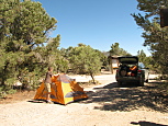
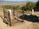
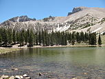
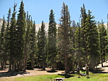
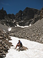
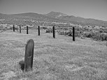
The next morning, we woke at sunrise, packed up camp, and started driving north towards Great Basin National Park. Along the way, we planned to explore the Osceola ghost town. While we had no trouble finding the cemetery, the town itself appeared to be fenced off with 'No Trespassing' signs. The majority of the graves in the cemetary dated back to the late 19th & early 20th century, although nearly all had plastic flowers on them. To make matters more interesting, the 'road' (which was basically dirt single track, passing over the mountains) didn't follow Google's Map at all, and there were a few occasions when we were very unsure if we were going to end up stuck or have to turn back the \~13 miles. There were a few stretches of the road where the weeds growing down the center of the road were over a foot tall, and the trees and bushes along side closed in on the road. There were two points where the road led to closed gates. Thankfully, neither were locked, but there was the dreaded feeling each time, having to get out of the car to open them. In the end, it worked out fine, but it was still a bit disappointing that we never got to see the actual town site. We reached the park at late morning, and proceeded to find a good campsite. There are three campgrounds with running water, each at a higher elevation. We automatically ruled out the first (Lower Lehman Creek), as it was very full full of RVs. The second (Upper Lehman Creek) looked like a confusing maze of narrow roads, with campsites surrounded with overgrown weeds. This meant that we were to drive up to the 9800ft. elevation for the third campground (Wheeler Peak). This campground looked nice, although we had lingering concerns about the overnight temperatures at that elevation. We ended up choosing campsite #10 for two nights. The campground was quite pretty, with a lot of conifers everywhere, and a bizarre infestation of moths flying about. We got unpacked, had lunch, and then set out for a short (2.7 mile) hike on the Alpine Lakes Loop trail. The trail was gorgeous, winding its way up initially through the forest (just above 10,000ft.), then past two alpine lakes at the foot of Mount Wheeler. Although we didn't have any issues with the elevation while hiking, later that afternoon we both started to get pounding headaches, and felt exhausted. We literally fell asleep sitting in the car after the hike, for a few brief naps. After dinner, we drove back down the mountain to Upper Lehman Creek campground, for the evening ranger program. While not the most exciting topic (Bonneville Cutthroat trout), the ranger made a great effort to put forth an interesting discussion of this endangered native fish, unique to the park's creeks.
<p>
<center>
</center>
</p>
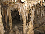
It was quite chilly that night, dipping into the upper 40s. When we awoke the next morning, we had breakfast, and then made the drive most of the way down the mountain to the Lehman Caves Visitor Center. On the drive down, the temperature climbed nearly 20 degrees. We had tickets for the 9AM Grand Palace Lehman Cave tour. Unfortunately so did a boy scout troupe, full of loud, obnoxious, rude teenagers, who felt that it was fun to annoy everyone around them. Throughout the entire tour, they were cracking jokes, and being rude & disruptive. The tour itself was ok, but for its 90 minute run time, didn't cover all that much distance inside the cave. Afterwards, we made the drive back up the mountain (nearly 3000ft.) to the campground, where we had lunch. Then Denise took a nap, as David & I hiked the Bristlecone & Glacier trail (up to about 10600ft.). The trail itself was awesome. It started off in the forest, but eventually wound its way along a cliff, then up through a very rocky hillside, crossing a talus slope, to the base of the glacier on Wheeler Peak. David was absolutely thrilled to see and (briefly) play in the snow. The views up there were stunning, and the trail wasn't all that busy, so we had it mostly to ourselves. Even with all the elevation gain, we managed to complete the 4.6 miles in just under two hours. We spent the afternoon relaxing back at the campground. After dinner, we drove back down the mountain for the evening Astronomy program. The program was really nicely done, with a great presentation, followed by telescopes. We saw both Saturn & Mars. Then it was back up the mountain to the campsite, and we went to bed for the night.
<p>
<center>

</center>
</p>
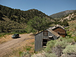
Somehow, it was significantly warmer and windier that night (at least 15 degrees), and we awoke the next morning somewhat disorientated by the unusually warm weather. We packed up the campsite, and headed out of the park, westbound, to the ghost town of Belmont Mill. Approaching from the west, Google routed us along some rather sketchy 'roads', which looked like they hadn't seen any traffic in many months, if not longer. They were incredibly overgrown with weeds, and the trees encroached tightly on both sides. To add to the fun, the roads themselves were somewhat uneven in a number of places, with fist sized rocks. All of this made it slow going, making us a bit nervous that we were going to end up misrouted, a long distance from civilization. Thankfully, it all worked out, and we found the mill, which was possibly the most stunningly well preserved site of the entire trip (excluding Bodie, which was a real state park). There were a number of buildings still standing, in varying states of decay, plus the entire mill itself. We explored the entire site, as safely as possible. The mill still had two huge ore carts fully loaded, as if the miners abandoned the site suddenly one day. The drive back to the highway (US-50) was in much better condition (flat, wide & mostly straight), and we proceeded to drive towards our destination for the night, up in Elko. That night we stayed in a motel, cleaned off the road dust, and ate dinner at the Star Hotel, a Basque restaurant. Apparently the big thing with Basque food is to serve & eat a lot of it. Like crazy sized portions of everything. The food was good, but I have to say that they seem to lean more towards the quantity than quality spectrum.
<p>
<center>
</center>
</p>
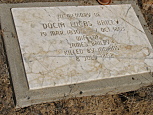
On the last day, we got up early, stopped for a hearty breakfast and hit the road westbound. We wanted to check out Unionville ghost town. We had no difficulty finding the cemetery, with a really awesome collection of graves from the 19th century (including one which noted that they were killed by Indians). However, the town itself seemed to have been completely fenced off as private property. So what few historic buildings that did exist could only be seen from the road, which was rather disappointing. We drove the rest of the way home in relatively light traffic.
It was a nice trip, and it was great exploring an area of the country that I'd never spent any real time in. All the trip pictures are posted HERE.